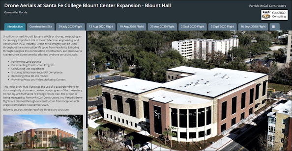
This was a 19-month project to capture drone video and photos that documented the construction of Santa Fe College Blount Hall in downtown Gainesville, FL. The three-story, 87,366 square-foot facility includes classrooms and lab suites, along with student support and service areas. To effectively disseminate drone footage to stakeholders, an online Story Map was developed that archived every drone mission at the site via videos, photographs, and narrative text. The story map can be accessed here: SFC Blount Hall Story Map.
Wednesday, March 30, 2022
Monday, March 28, 2022
Flights at the Florida Aquatic Swimming & Training (FAST) Facility
Monthly flights are being conducted at the Florida Aquatic Swimming and Training (FAST) facility in Ocala, FL. The new, state-of-the-art aquatics facility will be one of the largest in the country, featuring indoor and outdoor 50-meter competition pools. The indoor pool is expected to have the capacity to hold over 2,000 spectators. Aerial photographs and videos are being captured to document construction progress, provide timely visual updates of the construction to stakeholders, and afford social media and advertising content. Below is a collage of video clips with music soundtrack from a flight at the site in the Summer of 2021.
Sunday, March 21, 2021
Construction of Myra Terwilliger Elementary School
This was a 14-month project to capture bi-weekly drone footage to document the construction of the new Myra Terwilliger elementary school in Gainesville, FL. Midway through the project, a 20-acre mapping flight was performed to generate 2D and 3D models of the site. Specifically, a flight path grid was programmed at an altitude of 260 ft, and 137 nadir photos were captured that resulted in models exhibiting a ground sample distance of less than an inch. An animation of the interactive 3D model is shown below.
Friday, March 19, 2021
Construction Site 360-Degree Panoramic View
Monthly drone flights are being performed at the construction site of a new football facility at the University of Florida. In addition to capturing video and photographs to document progress, a flight was conducted to generate a panoramic view of the site. Here, the drone captured a series of overlapping photographs at different camera depression angles as it rotated in-place 360 degrees. The photos were then stitched together to yield an interactive, 360-degree panorama. Below is the rendered panorama which is hosted on Kuula. The panorama can be panned, zoomed, and rotated to quickly visualize the entire site.
Monday, February 17, 2020
Flights at San Felasco Tech City
Wednesday, January 15, 2020
Mapping Flight at Groundwater Remediation Site
Thursday, July 4, 2019
Construction of UF Health Fixel Institute
Monday, September 3, 2018
Mapping Flight at School Construction Site
Thursday, May 4, 2017
School Construction Site
Below is a GIS map produced following the mission that details the drone flight path and photo locations. Note, the basemap depicts "stale" aerial imagery taken before the site was cleared.
Tuesday, May 2, 2017
Church Construction Site
Below is a GIS map produced following the flight depicting the drone flight path and locations where photos were taken. The geo-referenced nadir photo is evident in the map.
Saturday, April 15, 2017
Real Estate - Commercial Property

Several beach front photos of the commercial property were also captured. In the interactive map below, click on a yellow icon to display the photo taken at that location. Clicking on the displayed photo provides an enlarged photo of the scene.
Monday, March 6, 2017
Real Estate -- Rural Property
Tuesday, February 21, 2017
Real Estate -- Single Family Residence
Monday, February 20, 2017
Waypoint Flight at Wetland Mitigation Bank
Saturday, February 18, 2017
Fairway Flights at Gainesville Country Club
Thursday, February 16, 2017
Sink Hole Volumetric Calculations
The DSM was imported into ArcGIS and volumetric calculations were performed using an array of spatial analysis tools. A summary of the results is available at Analysis Summary and Interactive Point Cloud which includes a link to the interactive three-dimensional point cloud.


